

Market Place to the parish church
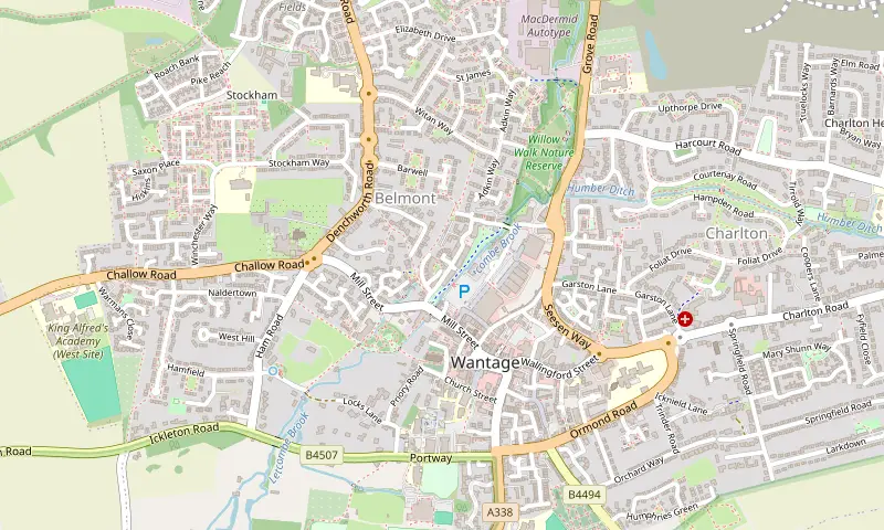
We start beside the marble statue of King Alfred, who was born in Wantage in 849. The statue has stood here since 1877; it was carved by Count Gleichen and paid for by Robert Loyd-Lindsay, later Lord Wantage, whose monument we can visit on the downs on another walk. With our backs to the shops we head west along Church Street to the church of SS Peter and Paul, a large mostly 13th-century building, and cut through the churchyard. Across the road is the Vale and Downland Museum, which has a café and is a good place to finish.
Priory Road and the Locks Lane ford
We follow Priory Road, once called Tanner Street after the tanneries that drew water from the brook, then turn right down Locks Lane. At the bottom the lane meets the Letcombe Brook at a ford and we cross by the footbridge. The brook is a chalk stream, fed by springs below the downs at Letcombe Regis and Letcombe Bassett. That is why the water is so clear. If we want a short detour, the path up the bank to the left leads to Alfred’s Well, a small wooded dell where springs seep out of the chalk. Lord Wantage had it laid out as a fern garden, and a later member of the family gave it to the town in 1921.
Along the mill leat to Betjeman Millennium Park
Back at the footbridge we follow the path downstream beside the leat, the channel that once carried water to the mills. We pass sluices and old stonework, then reach the iron bridge where Betjeman Lane climbs back towards the church. On our left is Betjeman Millennium Park, a patch of young woodland with a poetry trail: lines from John Betjeman’s poems are carved into stones by the sculptor Alec Peever. Betjeman lived in Wantage from 1951 to 1972 and wrote about the town in ‘Wantage Bells’ and ‘On Leaving Wantage’. It is worth a wander round the loop of paths before we carry on beside the brook.
The mills and the Wharf
The path squeezes between tall brick mill buildings and comes out on Mill Street, which is busy, so we cross with care. The deep water below the mill is a good place to look for brown trout holding station in the current. Across the road is the Wharf. This was the end of the Wantage Arm of the Wilts & Berks Canal, and the small building with the enamel sign for the West of England Sack Hiring Company is a reminder of the grain trade. We follow the cycle path with the brook beside us, then take the paths through the Belmont estate, which roughly trace the line of the filled-in canal.
Willow Walk and back to town
From Adkin Way we drop into Willow Walk nature reserve, a strip of willow copse, wet grassland and old pollarded willows along the brook. The paths here are grass and can be soft underfoot. In summer the grassland is known for scarlet tiger moths, which fly by day. We loop through the reserve to Grove Road, turn right along the pavement and follow Grove Street back up to the Market Place.
What to look out for
Kingfishers are regularly seen along the brook through town, often just as a flash of blue low over the water; listen for a thin, high whistle. Otters and water voles have returned to the Letcombe Brook, according to the Letcombe Brook Project, although both are shy and we would be lucky to see either. In spring, listen in Betjeman Millennium Park for chiffchaffs calling their own name and the richer song of blackcaps. Grey wagtails can often be seen bobbing on the stones by the mills. Please do not feed the ducks: bread harms them and the brook.
Before you go
No special kit is needed, but shoes with some grip help on the grass in Willow Walk after rain. The museum has local maps and leaflets; the relevant OS map is Explorer 170 (Abingdon, Wantage and Vale of White Horse). The whole loop is within the town, so it works well in the late afternoon or on a short winter day.
Make it longer or shorter
For a shorter walk, cross the iron bridge at Betjeman Millennium Park and climb Betjeman Lane back to the church, which gives a half-hour circuit. To make it longer, carry on from Willow Walk along the old canal line to Mably Way and join our Wantage Arm and Wilts & Berks Canal walk, or walk out to Letcombe Regis on the surfaced field path from Manor Road and back (about 2 miles more).


